Adwisor.AGRSmart farming. Practical advice.
THE Adwisor.AGR ECOSYSTEM

Smart tools for your farm.
Clear advice for you.

Soil sensors, satellite images and drone surveys help us understand your farm. Connected tools bring the findings to your phone, while our farming team helps you decide what to do.

TOOLS CHOSEN FOR YOUR LAND

From field readings
to practical farm work.

We combine the tools your crop needs. Start small or plan a system across your whole operation.

Know your soil and weather

Modular, low-power sensors can run on solar energy and grow with your farm.

  • Track soil moisture and NPK nutrients: nitrogen, phosphorus and potassium.
  • Monitor local temperature, humidity and other growing conditions.
  • Choose a simple starter setup or a connected network across many fields.
Plan crop care and harvests

AI compares sensor readings and satellite images to help your farming team spot changes.

  • Flag conditions that may increase pest risk.
  • Support harvest-window planning: when to inspect and prepare for picking.
  • Use data analysis to guide crop health and yield-improvement decisions.

Map and manage your fields

GPS mapping and drone images help locate crop changes and plan work across your land.

  • Combine GPS field locations with sensor monitoring.
  • Use detailed aerial images and automated mapping workflows.
  • Discuss drone-assisted crop spraying as part of your farm assessment.

Water where it is needed

Cloud-connected valves use soil readings to support automated micro-irrigation.

  • Match watering decisions to conditions in each crop area.
  • For larger farms, vary water and nutrient delivery by area through fertigation.
  • Plan connections to existing field machinery and irrigation valves.

The field assessment determines the tools and services suited to your farm. Crop forecasts guide field checks; they do not guarantee pest prevention, yields or savings.

Discuss your farm’s needs
IoT vs AIoT · A SIMPLE FARMING EXAMPLE

From farm readings
to your next step.

Connected sensors measure your farm. AI adds context from weather and imagery to help you understand what needs attention.

CONNECTED MEASUREMENTS

Traditional IoT

See the readings. A farmer or a predefined rule decides what happens next.

  1. Soil sensor
  2. Gateway
  3. Cloud
  4. Dashboard
  5. Farmer / rule
  6. Irrigation
ILLUSTRATIVE SENSOR READING

18%

Soil moisture

A measurement to interpret using your crop, soil and growing conditions.

Dashboards and alerts based on set thresholds.

CONNECTED INTELLIGENCE

Adwisor.AGR AIoT

Combine field signals with AI analysis and farming expertise to guide your next step.

  1. Sensors + imagery
  2. AI / ML analysis
  3. Expert review
  4. Farmer alert
  5. Field action
ILLUSTRATIVE FARMER ALERT

Zone 4 may be showing water stress.

Low soil moisture and changing crop patterns suggest this area needs a closer look.

YOUR NEXT STEP

Check soil conditions and irrigation in Zone 4.

Crop health, water stress and practical recommendations.

A more complete view: soil moisture · temperature · humidity · weather · satellite imagery · drone scans

IoT tells you what is happening.
AIoT helps you understand it and decide what to do next.

Illustrative examples. Recommendations depend on crop and field conditions, with farming experts guiding the final decision.

SATELLITE + DRONE INTELLIGENCE

See your farm
from a new perspective.

From a wide-area satellite view to a close-up drone survey. Understand the patterns, then bring the right expertise to the field.

Satellite sweepILLUSTRATIVE VIEW
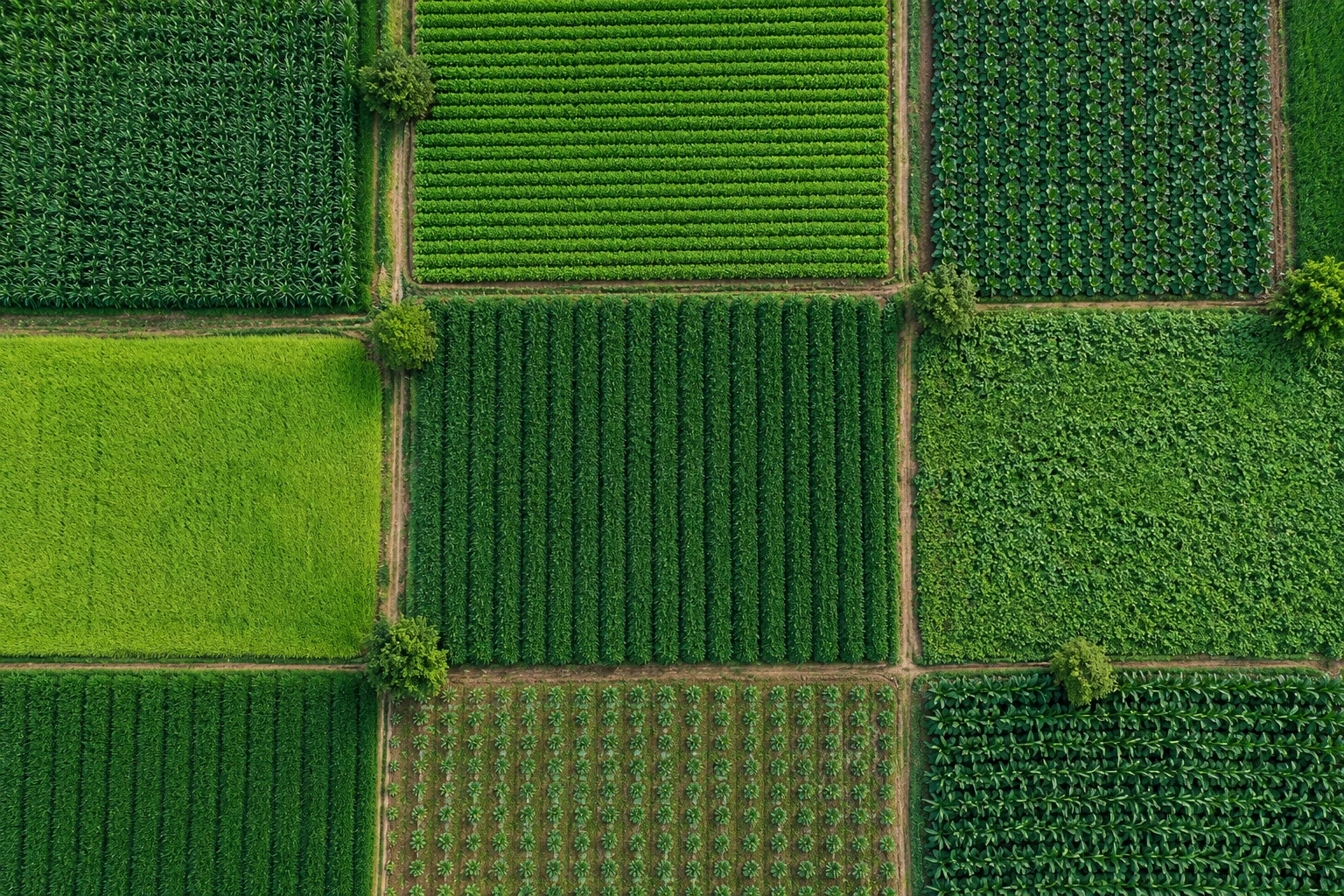
Illustrative overhead view of green crop plots and field paths
Canopy variationA signal to investigate on the ground
Illustrative scan · not live field data
WIDE-AREA CROP VISIBILITY

The bigger picture, from above.

Satellite imagery helps reveal patterns across your farm and changes between growing periods. Identify which blocks deserve a closer look.

  1. 01View the wider growing area
  2. 02Compare crop patterns over time
  3. 03Prioritize blocks for inspection
Discuss aerial scanning for your farm
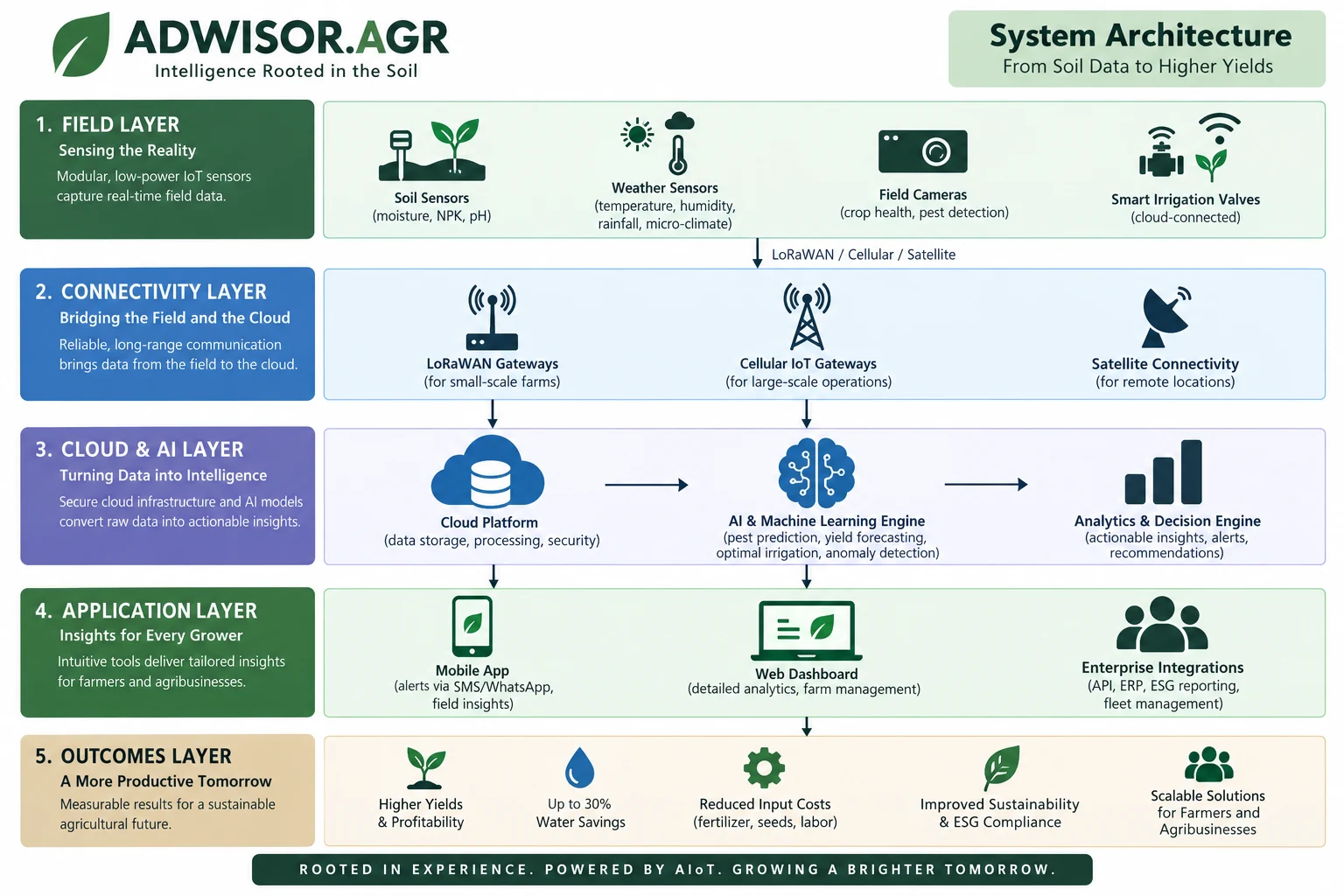
01
FIELD

Sense the field

Soil sensors, satellite imagery, and drone surveys bring your growing conditions into view.

Soil sensorsWeather stationsSatellite imageryDrone surveysField camerasSmart valves
02
CONNECTIVITY

Connect the dots

Reliable field-to-cloud communication, matched to your farm size and available coverage.

LoRaWANCellular IoTSatellite connectivity
03
CLOUD & AI

Turn data into insight

Secure cloud processing and predictive models surface crop risks, irrigation needs, and decision support.

Secure cloudPredictive modelsAnalytics
04
APPLICATION

Put insight in your hands

Practical recommendations for growers and connected dashboards for agribusiness teams.

Mobile insightsSMS / WhatsAppWeb dashboardERP integrations
05
OUTCOMES

Grow with confidence

Better-informed decisions support resource efficiency, crop health, and more sustainable operations.

Resource efficiencyCrop healthSustainability
FROM SOIL DATA TO HIGHER YIELDS

The complete picture.

Open full-size architecture
Five layers of the Adwisor.AGR system: field sensors and smart valves; LoRaWAN, cellular and satellite connectivity; cloud, AI and analytics; mobile, web and enterprise applications; and resource efficiency, crop health and sustainability outcomes.

Every deployment is scoped to your crop, connectivity, and infrastructure. The architecture illustrates our framework; integrations and outcomes depend on your field assessment.

LET’S START WITH YOUR FARM

Tell us about your farm.
We’ll help with the next step.

Start with a free farm technology assessment.

Talk to a farming expert